Monday, 5 September 2011

Tuesday 19th July 2011 Garsdale, Yorkshire Dales

This was a short 2.5 mile 'loosener' walk after the main event in Horton, done with Lynda and Trevor who was visiting us in Dent for a couple of days. We started at Garsdale Station where we stopped for photos and admired the scenery around us. The picturesque station has a small visitors centre with a number of old photos showing the building of the railway, the station and characters involved. It is not quite as high up as Dent but has the same feel of remoteness even though Leeds station is only 80 minutes away!

Trevor & Lynda (smiling)
We left the station and crossed onto the moor, following a vague track across a stream and onto a derelict (?) farmhouse at High Scale. We then dropped down to the main road at Low Scale (!). We went through the farmyard pausing to admire the abandoned caravan and started uphill towards the row of cottages at Knudmanings where we chatted with a resident who advised us of the path ahead.

We followed the road, crossing cattle grids and eventually met the main road again, towards the station. After the rigours of this epic walk, we repaired to the Moorcock Inn where we enjoyed pints of Copper Dragon beer.

Moorcock Inn, Garsdale
Copper Dragon Brewery


An OS view walk is below, courtesy of QUO digital mapping/OS


Saturday 16th July 2011 Yorkshire Three Peaks Challenge, Yorkshire Dales

After all of the hype and (some) training, the day had arrived. Lynda and I stayed overnight Thursday and Friday nights at a B&B wisely booked back in January when the challenge was mooted.


The Willows B&B, Horton in Ribblesdale

Rain was predicted by locals, the Met Office and anyone we asked, but we kept hopeful as Friday night at the Crown turned into an early Saturday start. Breakfast at the Willows was 06:00 and we rendezvous-ed behind the Crown Hotel with the rest of the group under the Epilepsy Action banner - and no rain!


Andy - our guide
The Mountain & Glen team were our guides and advisers as we were split into teams ready for the off. We (myself, Lynda, Paul & Sarah) were in an Epilepsy Action team led by Andy the Taff, complete with walking poles, who I was to spend some time with during the day!


Mountain and Glen, great guys!


As we left the hotel, heading towards the church and the track up Pen-y-Ghent, we passed the public car park and loos where most folks made a last pit stop. As we waited, the rain started to come down. Waterproof over-trousers out of the pack and off we went, leaving Horton, heading up the road by the church towards Brackenbottom. The road has a gradual incline and just before you reach the farm there is a track to the left where the real walk starts. There is a constant uphill gradient, following the clear track onwards and upwards with Pen-y-Ghent out of sight, hidden by the rain and clouds.

We followed the track with a dry stone wall on my left before turning uphill to Brackenbottom scar where the track became a little more difficult, having to scramble over rocks at times. The field was now starting string out (to using racing parlance) with different groups heading up the mountain and people generally struggling with the conditions. Andy kept walking with the back markers of our group (no names) making sure they were OK and in good spirits, but the truth was that we were all soaked soon after leaving Horton - despite the array of expensive gear on show.

Andy leading, Lynda following...
We kept going up the track, wall on our left and the usual obstacles such as limestone steps and boulders on the way. We eventually hit the Pennine Way and followed the track left up the steep path with steps leading into the mist. The rain was really coming down at this stage and we couldn't see ahead or behind us for any distance. At a certain stage of the ascent, as I remembered from my previous visit in June, we had to scramble up the track, often waiting for the queue to subside - yes, there were really lots of people doing this thing! Red Cross had 350 folks up for the challenge and I have to say that some of them were poorly equipped - we even saw one idiot with Morrison's carrier bags over his trainers to help in the wet conditions!

Lynda, not smiling

After a steady scramble the track flattens out somewhat with a gentle approach to the trig point and the summit. There weren't many happy faces on the top but we did manage a few photos to capture the magic. As we waited for our group to assemble, Andy emerged from the mist with our back marker on this stretch - Lynda. She was not smiling! 

We assembled and hid from the rain and wind behind the stone shelter, ready for the descent and the track across the bogs towards Birkwith where the Mountain & Glen mini-bus would meet us with hot drinks etc. The descent is quite wide, but steep and on rough ground which skirts round the side of the mountain. There is the Pennine Way path off to the left which leads back to Horton and many of us wanted to take it! We continued on to the dreaded bogs on Horton Moor, Todber Moss & Red Moss and we were soon sinking into the mud as we crossed in the mist. The guides helped us traverse boggy streams and other traps, but we all saw people lose their boots and others sinking in to alarming levels before being helped out. This was miserable!

Paul, Sarah & Lynda
Lynda and Sarah were at the back of our party and Andy radioed for support so that he could push on with the main group. After much boggy progress, we reached the van at Birkwith and gratefully drank hot tea & coffee and grazed on energy bars while taking on more bottled water. Paul squeezed out his walking socks and got ready for the re-start as Lynda & Sarah arrived. It was here that they both retired after 8 miles, grateful for hot drinks and shelter. Their day was over!

We continued on the track, towards Nether Lodge and Lodge Hall, a long snake of intrepid walkers, undeterred by the conditions. It was here that cramp kicked in and Andy's advice was to consume crisps and salted nuts to recover salt in the system. As I had neither I made a mental note for future extreme hikes! The cramp was in both thighs and getting worse as we approached the next checkpoint on the Gauber Road where the van (and Lynda) were waiting. I was almost giving up at this stage but went along with the encouragement around me and continued towards Ribblehead, the station and the pub.

Viaduct on a good day!
At the Ribblehead T junction, we didn't stop to admire the viaduct as on previous walks, but headed across Batty Green, parallel to the railway and on towards Whernside. We followed the track, past the signal box and house, then as before with Dominic, we crossed the line at the aqueduct and started uphill, pausing only to take on water (not much left here as I had not refilled at the Gauber Road!) and graze on energy bars. I was quickly becoming the dreaded back marker of the group, struggling to keep up and so becoming Andy's best mate. I was struggling here and only with Andy's support and the 'Himalaya Pace' trick did I eventually make it to the summit of Whernside where we expected to meet the rest - as per Andy's instructions.

Whernside descent...
As we started the descent, having made sure the rest of the group were OK and with another M&G guide, the weather lifted a little (Alhamdulillah!) and I found the energy to take a photo. The descent was awful with the steep steps previously described in 28th June blog. These were made worse by the rain and the constant flow of what looked like cement slurry - very slippery. It took quite a while to get down and to the track ahead - the conditions and the number of people making the descent caused mayhem. Andy and I proceeded along the path while radio calls advised us that, if hot tea was required, then we should buy it at the Philpin Farm snack bar where they were doing a roaring trade and did not need the M&G (and other) competition. We reached the farm at around 16:00 and I really enjoyed the hot tea and a cheese butty while I looked for a towel to throw in. I wasn't going to make it to Ingleborough and so I joined other members of the group, who were also stopping, in the van ride back to Horton, 17 miles under our belts.

Paul Johnson and two ladies from our group made the full 25 miles and I admire them for doing so - it was not my day, but I'll be back!!

Tuesday, 5 July 2011

Tuesday 28th June 2011 Whernside & Ingleborough, Yorkshire Dales

This was my second visit to the Dales to see what the Yorkshire Three Peaks Challenge (July 16th) would actually mean to me. The Challenge includes the 25 miles over Pen-y-Ghent, Whernside and Ingleborough within 12 hours, so I thought I'd better see what this actually meant! Readers will recall that I managed Pen-y-Ghent earlier in June and so this was the return leg to see what Whernside and Ingleborough were all about. Dominic came along with me to try this 15 miler which we hoped to do in around 8 hours.


Dominic, Viaduct & Whernside
We traveled to Ribblehead via Leeds on Monday the 27th but got off to a bad start (Dominic's words) with train delays around Birmingham and this together with congestion at Leeds station meant that we missed our connection and had to wait another 3 hours for the next train! We eventually left Leeds at around 18:00 and reached the remote station of Ribblehead one hour and a bit later. We stayed at the Station Inn which was OK, but a bit scruffy, had a pint, a quick bite to eat and a game of pool before an early night ready for the walk ahead. I managed a few photos of the iconic viaduct in the mist but decided that daylight would provide a better photo.


Whernside
We left the Station after a big breakfast at about 09:30 in bright sunshine and turned left onto a well worn track running alongside the viaduct. We followed the track past a junction under the tracks and a signal box, following signs for Dent until we reached an aqueduct/bridge over the tracks. We crossed the tracks and started to climb in a left arc, now following Whernside signposts for around 2 kms. We met a few other folks doing the walk and the climb to the summit was OK with a few stops for breath. Dominic was racing ahead of course - his strategy was based on speed then rests until I caught up. We reached the summit and stopped for photos and of course fuel intake for Dominic. The views were spectacular with the viaduct, Station Inn etc all clearly visible from our vantage point of 736 metres in altitude. 


Ingleborough
We then followed the track and began the descent which was quite steep in places with loose rock and boggy patches. As we made the descent, we could see clearly the next challenge - the rising peak of Ingleborough, across the valley. The track downwards snaked off into the distance and our knees & thighs ached with the constant pressure of the downhill, but eventually we left the moors and joined arable farmland and eventually the main road at Philpin - the farm here provides a snack/toilet stop for weekend walkers! Once at the road (B6255) we saw the Old Hill Inn and stopped for a quick intake of (non-alcoholic) liquids. This seemed an excellent pub and I noted it for a future visit in July.


The Old Hill Inn, Chapel le Dale

More food
D ahead as usual
Just after the pub, we turned right and followed in non too distinctive path, keeping close to the wall on the right. The track eventually became clear and we started uphill, passing a huge gaping pot hole, known as Braithwaite Wife Pot. The track here is well maintained with a series of flag stones to keep you out of the bogs. Onwards and upwards we progressed with Dominic out front as usual, until we reached a spot where the incline changed drastically with stone steps leading almost vertically to the next stage of the climb. Eventually I reached the top and we stopped for more fuel intake - this being a feature of the day.

Ingleborough
We reached the summit plateau after another uphill stretch which was testing and precarious, but on the plateau we quickly reached the cairn, trig point (723 metres) and shelter, along with a half dozen other souls who had braved the climb, albeit from different directions. We stopped for photos and more food (!), before bracing ourselves for the 7 mile slog down to Horton in Ribblesdale where we had accommodation booked at the Crown.

We left in good spirits, having done two of the three peaks and the intention of mastering the third the following day! We could see Pen-y-Ghent in the distance and this provided a great navigation aid to reaching Horton.

Pen-y-Ghent
The path down from Ingleborough summit was rough and steep with loose rocks and bogs again the feature, supplemented by a number of limestone obstacles built into the track to keep you on your toes. By this stage, I was developing a wonderful blister and getting some pain in my feet but we kept on with Dominic out front. We met other walkers doing the same trip and also farmers repairing dry stone walls and after what seemed a very long descent via Sulber Pot and Sulber Nick, we reached Horton and the Crown where it became clear that Dominic had bad sun burn as well as very tired legs after this 8 hour walk of which 6.5 hours was actually walking/scrambling/climbing.

We had a quiet but excellent dinner and collapsed, already probably realizing that Pen-y-Ghent the following day was a little optimistic. This proved to be correct when we talked next morning, both aching and Dominic with burnt neck and legs - he laughed at my buff, but did I have a burnt neck? This walk of 8 hours plus my previous Pen-y-Ghent of almost 6 hours does not bode well for a 12 hour total but we'll see...

An OS view of the start and end walk is below, courtesy of QUO digital mapping/OS - please let me know if you want all 8 pages:


Saturday, 25 June 2011

Friday 24th June 2011 Birdlip to Daneway, Glos

Dominic
This was a 10 miles walk done in 4 hours with my son, Dominic, in readiness for the Dales next week. This is a walk I did previously with Robin, Mike & Sally in September 2009, starting in the same place and ending at the Daneway pub a long while later. On that occasion we were lucky enough to see the preparations for the Kemble Air Show with the WW II flight of Spitfires, Hurricanes and a Wellington getting into formation for the official show fly past.

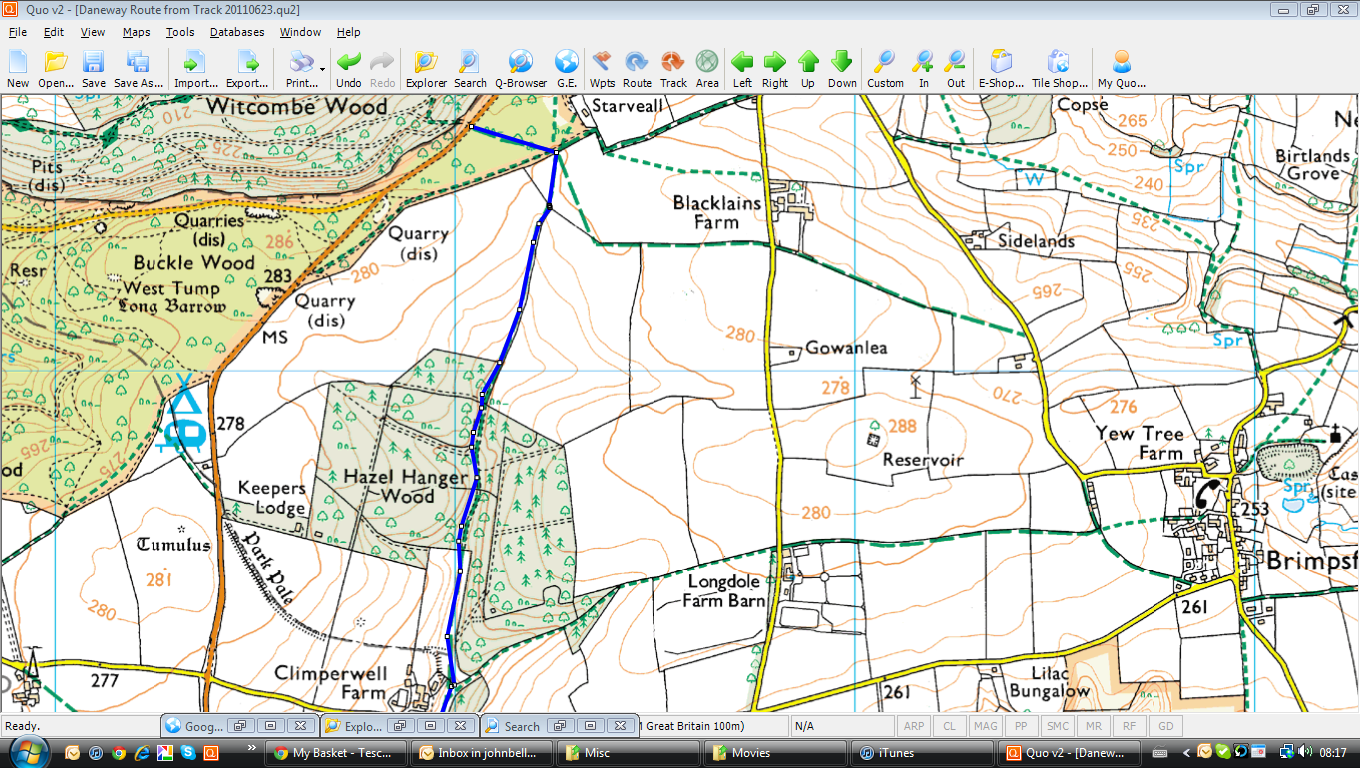
We parked in Birdlip, just at the start of Witcombe Woods and followed the track across a field towards Hazel Hanger Woods which leads to Climperwell Farm on the right as we came through to open ground where there were plenty of poppies and other flowers to be seen. We then went into Climperwell Woods where there is a long track following a stream with the Foston's Ash pub away to our right - we made a slight map reading error here, climbed a hill only to come back down again - most welcome! The woods merged into Barn Woods, New Seal Woods and Warren Hill with fields to our left and with Caudle Green to our left, we dropped into the woods again, passing pheasant cages & nets, onto Miserden Estate and very familiar land. We crossed the ford and made our way to the lake where we had a break for a few minutes.

Valley Farm
We followed the stream from the lake to Bull Bank Lakes where we made a sharp left off the main track and kept the stream to our right until we hit the road and passed house on the left before going through a gate onto the estate again by Parson's Hill. We crossed the stream at a familiar footbridge and followed the valley floor & the herd of black sheep, continuing along the valley floor past Valley Farm which was having major works done, the last time we passed this way. Eventually we joined the farm drive and reached the road around Edgeworth. Rather than follow the road or the zig-zag track we followed last time, I suggested a direct route which was signposted, but soon deteriorated and we found ourselves in dense woodland and no path. However, we persevered and soon found ourselves at Edgeworth where we crossed the churchyard and came out at the road beside the manor house. We had another liquids/chocolate break at the church gate.

We then followed a track, passing Cotswold stone houses until we reached a gate and the field beyond. Sheep then stopped and polo ponies became the most common animal with Edgeworth Polo Club providing us with an insight into how that particular sport is laid out. Massive pitches, but all pristine and a number of very attractive horses. When the polo field gave out, we passed over one last field and entered Dorvel Wood on the Bathurst Estate where we followed a good track to the Daneway Lane and the pub which is situated on the old Severn-Thames canal. Look at the history of the pub in the link below.

Daneway Inn History

Dominic & I had bacon & egg 'banjos' while we waited for Brett to come and pick us up - very nice, but just a touch overpriced - the banjos, that is, not Brett. Thanks to Brett!

One negative thing about this walk was that, in spite of my comfort with the walk & feeling fine afterwards, I was in a deal of pain in the evening to the degree that A&E was consulted this morning. Nothing broken, but 'traumatized ligaments' in the foot was the conclusion. Foot up & rest was recommended. Does not bode well for Dales on Monday!

The maps for this walk take 7 pages so I've included the first and last - if anyone wants the lot, then just ask!

An OS view of the walk is below, courtesy of QUO digital mapping/OS:


Thursday, 16 June 2011

Wednesday 8th June 2011 Miserden, Glos

Mike P
This is now almost becoming the 'house' walk as I've done it so many times with friends and family. It is the 6 miles or so walk, starting at the village of Miserden and including the villages of Duntisbourne Abbots and Winstone. On this occasion I walked it with Mike P who was keen to 'learn'the walk for a future outing with Sally. We didn't race round this walk due to my condition after Pen-y-Ghent the previous day and Mike's poorly knee, but managed a respectable 3 hours.

Carpenters Arms
Mike drove to Miserden via Birdlip and Whiteway, parking near the Carpenters Arms pub as usual on a damp morning. We passed the tree with the seats around it and passed between houses where the signpost shows the path, continued with a stone wall to my left which quickly becomes the boundary wall of the Miserden Estate - large greenhouses can be seen on the left. 

We crossed a road in drizzle and went across arable farmland, following a well defined path until three path options were offered. We took the right path along the fence line and then headed left into a field, spotting three deer, before entering woodland where the path becomes somewhat steeper veering to the left at the bottom of the incline, following a stream. We followed the stream and crossed via the footbridge, crossed the meadow and started to climb the track which levels out and continues along a long path to the picturesque village of Duntisbourne Abbots where we stopped for a break and coffee on a village bench - very nice! 

We then followed the road down past the vicarage towards Birdlip and joined a footpath on the left through fields towards Winstone where we again left the road and went across fields to Gaskill's Farm.
Passing the farm, we were quickly at the lodge, the entrance to the estate and followed the drive until we joined a grassy, muddy path going downhill to the lake. We kept to the left of the lake, joined a rough track left and started to climb up the other side of the hill along a sunken muddy cart track before joining the road again. There were great views of the estate and especially the lake and Miserden Manor from the vantage point. We quickly rejoined the main road and found the pathway back to Miserden village, declining to stop at the Carpenters on this occasion, due to my impending dental appointment!


An OS view of the walk is below, courtesy of QUO digital mapping/OS:


Wednesday, 15 June 2011

Tuesday 7th June 2011 Pen-y-Ghent, Yorkshire Dales

Pen-y-Ghent
This was a visit to the Dales to see what the Yorkshire Three Peaks Challenge (July 16th) would actually mean to me. The Challenge includes the 25 miles over Pen-y-Ghent, Whernside and Ingleborough within 12 hours, so I thought I'd better see what this actually meant! I traveled to Horton in Ribblesdale via Leeds on Monday the 6th and stayed overnight in the Crown Hotel, a local pub near the station with rooms. Staff friendly/cheerful, rooms are basic, beer good and food OK if you like variations on pie & chips (wild boar, venison, plus the usual...). The pub was rocking on a Monday night, so it must be bedlam at weekends. There were several groups of walkers in the two pub rooms, all taking on liquids/carbs for the next days' travails.

As I walked from the station to the Crown I got my first view of the task ahead (above)...

Crown Hotel, Horton in Ribblesdale

I was up early, had a good breakfast and set off, fully loaded with rucksack, poles etc for the 10 miles over Pen-y-Ghent to Ribblehead and, hopefully, the Station Inn. I passed by the Pen-y-Ghent cafe (closed Tuesdays) and walked the road to Brackenbottom, turning off the main road at the church. The road has a gradual incline and just before you reach the farm there is a track to the left where the real walk starts. There is a constant uphill gradient, following the clear track onwards and upwards with Pen-y-Ghent looming in the distance.

The rain started almost immediately and was a feature of the day, sometimes torrential. I followed the track with a dry stone wall on my left before turning uphill to Brackenbottom scar where the track became a little more difficult, having to scramble over rocks at times. By this time I had got all of my waterproofs on, including a rain cover for my rucksack and turned left over a stile to join the Pennine Way up towards the mountain itself.

The mist then came down and the walk was suddenly becoming unpleasant with heavy rain, mist and difficult terrain. I followed the track, sometimes based on large stone flags, with a wall to my left on the upward slog, passing a dead sheep (!) before scrambling again over the slippery rocks, struggling at time to see where the real path was. I realized that I was making hopeless time, having done the approach reasonably well, I was now scrambling up at a very slow rate.

I eventually hit the top, seeing other fellow walkers through the mist and recognizing the cairn and the trig point indicating the top (694 metres - in England and Wales the Department for Environment, Food and Rural Affairs has defined "mountain" (as a mass noun) as all land over 600 metres). I stopped for a couple of minutes before setting off down the other side of the hill starting the long slog towards Ribblehead.
Boggy!


I crossed the wall, and continued north along the Pennine Way from the summit. As the descent steepens, the Pennine Way turns left at a junction and I continued straight ahead on the path heading over Horton Moor. The ground underfoot now became much more entertaining (boggy!) and you needed to be careful where you placd your feet. I crossed Hull Pot Beck at the stepping stones and followed the 'path' over Todber Moss, heading northwest across two walls to Burnrigg, crossing another wall and small stream before meeting the Pennine Way once again. I headed straight across the Way, and follow the better track down to the track junction above High Birkwith.

I followed the Pennine Way to Nether Lodge before taking the tarmac drive all the way to Gauber Road (B6479) where I turned right, being very careful as this road has no footpath and the traffic moves quickly. I continued heading north until I reached the 'T' junction (B6255) at Ribblehead where the rain was really coming down. I saw the magnificent Ribblehead viaduct in the mist but didn't take a photo due to the conditions.

I made for the Station Inn, pausing with other walkers to get shelter for a while before making for the nearby station to catch a train back to Leeds and on to Cheltenham - pausing in Leeds to meet Frank Foster at the station Wetherspoons for a welcome intake of liquids and food. This walk took me six (yes, 6) hours to go 10 miles or so - not very promising, but the weather was attrocious and I was a bit poorly from the previous week's ''gastro fun''. Hopefully, I'll do better on my next outing in the Dales, scheduled for the week of the 28th June when I'll do the 14 miles over Whernside & Ingleborough, plus this same walk again.

Station Inn, Ribblehead

An OS view of the walk is below, courtesy of (Patrick) and QUO digital mapping/OS:


Saturday 28th May 2011 Miserden & Caudle Green, Glos

This was the shorter of the Miserden walks that I do i.e. the 3.5 mile jaunt which took us 1.5 hours on this occasion, pausing to take photos etc and admire the wildlife. I did the walk with Lynda, Ros & Dave and we set off from the usual parking place at the Carpenters in fine drizzle (originally going to do the six miler but conditions didn't suit my party!)


We left the car at around 11:15 and quickly left the village going towards the walled Miserden Estate. We skirted the boundary wall and entered the estate via the gate and started downhill on the old sunken cart track, stopping to let Dave take a photo of the Jacobean manor house and the lake & hills beyond. We kept on towards the lake and followed it until we met a stream along side the track which guided us towards Caudle Green by way of a track which included a ford and a short climb to join the road into the village.

We passed a number of typical Cotswold houses and climbed a final short hill to join the main village square before again cutting through fields and into the woods once more. The rain was coming down by this time so we hurried on across the ford and through a large gate on our right, up the gentle slope and into the main estate grounds where a long winding road guided us back towards the village of Miserden. In the grounds there were many sheep and several inquisitive horses who came over looking for food I suppose. We obliged with photographs.

When we reached the village, the rain was really coming down so the only thing to do was to repair to the Carpenters, Wye Valley HPA, soup and sandwiches... sounds familiar.

An OS view of the walk is below, courtesy of QUO digital mapping/OS: