 |
| Pen-y-Ghent |
As I walked from the station to the Crown I got my first view of the task ahead (above)...
Crown Hotel, Horton in Ribblesdale
 I was up early, had a good breakfast and set off, fully loaded with rucksack, poles etc for the 10 miles over Pen-y-Ghent to Ribblehead and, hopefully, the Station Inn. I passed by the Pen-y-Ghent cafe (closed Tuesdays) and walked the road to Brackenbottom, turning off the main road at the church. The road has a gradual incline and just before you reach the farm there is a track to the left where the real walk starts. There is a constant uphill gradient, following the clear track onwards and upwards with Pen-y-Ghent looming in the distance.
The rain started almost immediately and was a feature of the day, sometimes torrential. I followed the track with a dry stone wall on my left before turning uphill to Brackenbottom scar where the track became a little more difficult, having to scramble over rocks at times. By this time I had got all of my waterproofs on, including a rain cover for my rucksack and turned left over a stile to join the Pennine Way up towards the mountain itself.
The mist then came down and the walk was suddenly becoming unpleasant with heavy rain, mist and difficult terrain. I followed the track, sometimes based on large stone flags, with a wall to my left on the upward slog, passing a dead sheep (!) before scrambling again over the slippery rocks, struggling at time to see where the real path was. I realized that I was making hopeless time, having done the approach reasonably well, I was now scrambling up at a very slow rate.
I eventually hit the top, seeing other fellow walkers through the mist and recognizing the cairn and the trig point indicating the top (694 metres - in England and Wales the Department for Environment, Food and Rural Affairs has defined "mountain" (as a mass noun) as all land over 600 metres). I stopped for a couple of minutes before setting off down the other side of the hill starting the long slog towards Ribblehead.
 |
| Boggy! |
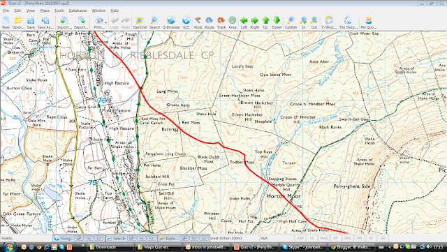
I crossed the wall, and continued north along the Pennine Way from the summit. As the descent steepens, the Pennine Way turns left at a junction and I continued straight ahead on the path heading over Horton Moor. The ground underfoot now became much more entertaining (boggy!) and you needed to be careful where you placd your feet. I crossed Hull Pot Beck at the stepping stones and followed the 'path' over Todber Moss, heading northwest across two walls to Burnrigg, crossing another wall and small stream before meeting the Pennine Way once again. I headed straight across the Way, and follow the better track down to the track junction above High Birkwith.
 I followed the Pennine Way to Nether Lodge before taking the tarmac drive all the way to Gauber Road (B6479) where I turned right, being very careful as this road has no footpath and the traffic moves quickly. I continued heading north until I reached the 'T' junction (B6255) at Ribblehead where the rain was really coming down. I saw the magnificent Ribblehead viaduct in the mist but didn't take a photo due to the conditions.
I made for the Station Inn, pausing with other walkers to get shelter for a while before making for the nearby station to catch a train back to Leeds and on to Cheltenham - pausing in Leeds to meet Frank Foster at the station Wetherspoons for a welcome intake of liquids and food. This walk took me six (yes, 6) hours to go 10 miles or so - not very promising, but the weather was attrocious and I was a bit poorly from the previous week's ''gastro fun''. Hopefully, I'll do better on my next outing in the Dales, scheduled for the week of the 28th June when I'll do the 14 miles over Whernside & Ingleborough, plus this same walk again.
Station Inn, Ribblehead
An OS view of the walk is below, courtesy of (Patrick) and QUO digital mapping/OS:


No comments:
Post a Comment