Wednesday, 13 June 2012

13th June 2012 Bradford on Avon to Bath

The start...
Mike, Brian and myself took the train from Cheltenham via Bristol to Bradford on Avon via Bath to walk the Kennet and Avon canal to Bath which is just under 10 miles. The Kennet and Avon Canal has an overall length of 87 miles made up of two lengths of navigable river linked by a canal. The name is commonly used to refer to the entire length of the navigation rather than solely to the central canal section. From Bristol to Bath the waterway follows the natural course of the River Avon before the canal links it to the River Kennet at Newbury, and from there to Reading on the River Thames. In all, the waterway incorporates more than 100 locks. But today - Bradford on Avon to Bath - only!We picked a nice day, sunny and no prospects of rain.


The Cross Guns
Mike & coffee
We left Bradford station, turned right at the road and right again just before the bridge through a yard to the canal where we started our walk on the right bank. All along the length of the canal there were barges and narrowboats in various states or repair, mostly in poor condition we noted. We walked steadily for a couple of miles and came to the Cross Guns pub where we stopped for coffee. This seems a very popular walking and cycling pub with lots of outdoor seating and tables close to the canal. We left the pub and crossed under the canal to join the towpath over the Arncliff aqueduct, passing the station on our right and continued our walk, with the canal heading off to the left and then right. I must say that the walk was a little boring so far with just the canal, the towpath and the trees to look at. There are no views from the towpath due to the overhanging trees and bushes, but things might improve. We stopped for coffee (again!) along the way, taking advantage of the benches along the towpath and repeatedly making comments about the poor state of some of the boats along the way.
We followed the canal, bending to the right again at the weir and arrived at Dundas Aqueduct, built by John Rennie and completed in 1805. We crossed the aqueduct and saw a number of people at the far end - mostly with cameras and binoculars. What could it be?

Add caption
Diesel anyone?
As we arrived at the far side, we could see on the left the main Wessex railway line and in the distance a cloud of smoke from a steam locomotive. Very exciting! The train passed below us and gave everyone the opportunity for photographs, even as it passed into the distance to our right. We rounded the basin at the end of the aqueduct and continued on our way with the canal on our left. As we approached Claverton we passed a water-borne petrol station which also served as a mobile shop to the boating community. Now, with the Avon and the railway on our right, we made our way to Bathampton and as we rounded the canal turn there, we spotted the pub - the George Inn, where we stopped for a couple of pints of Tribute and thought about food. The George Inn at Bathampton dates back to the 13th Century and was originally a monastery, established by the Prior of Bath. However, it was full of diners at the time, so we opted to drink outside by the canal with only a short distance left to Bath itself.


Bath at last!
Refreshed, we continued towards Bath and quickly on the outskirts looking forward to lunch at the Pulteney Arms, a pub we'd visited on a rugby night in Bath some time before. The view from the canal became grander as we entered Bath until we reached Sydney Gardens where it becomes very grand indeed. We quickly crossed the gardens and made for the pub on Daniel St but, alas, it was closed (after 1500) and despair set in...


No food at Pulteney
In desperation we asked a builder nearby where the next nearest pub was and eventually we reached the Barley Mow an Bathwick St - not ideal and no food apart from crisps, nuts etc. - and poor beer to boot. We bided our time until 1700 talking nonsense and complaining (to each other) about the beer and then made for the Pulteney again to be told that the chef didn't start until 1800. More despair. A quick meeting resulted in agreement to forget pubs as food was the priority. Mike, our Bath expert, proposed Browns as the solution!
We then made for Browns, had more beer (Erdinger Weissbier - excellent rocket fuel) and an excellent late lunch/early dinner and made our way to the station for the train to Cheltenham, again via Bristol. The train worked a treat, we made use of the old folks concession cards and beats the car every time.


An OS view of the walk is below, courtesy of QUO digital mapping/OS


Monday, 30 January 2012

29th January 2012 Chedworth, Glos

This was a Sunday morning walk with a pub lunch at the end of it! Jools dropped Robin, Mike and myself just off the A436 near Kilkenny. The objective was to walk to the Chedworth and have a pub lunch at the Seven Tuns.

Seven Tuns Chedworth


We walked up the road a little and then crossed into fields to our left as we reached the top of the hill. The weather was OK but quite misty stroke foggy so the views that Robin promised didn't really appear.


Coffee break
We then followed the walls on our right, noting the number of gates and places for horses to jump (at a a reduced height). We continued through field and along tracks, pausing for coffee and other pit stops - Mike can be seen below next to one of these horse jumps.

Mike at a horse jump
We progressed with Withington village on our left, crossing the two main tarmac entries to the village until we entered the  shelter of Withington Woods where there clearly had been a lot of work done by the forestry as there were beautifully stacked logs along our path with signs for children not to play on them!

Yes, that's deer!
We looked for deer in the woods, and saw lots of them but of course no real photographic proof, except the blurred images I've included courtesy of my iPhone. This was my first walk with walking poles and despite the mickey taking, both Mike and Robin tried then and kind of approved. I've used them ever since and now wouldn't go out without them. The one disadvantage is that photography is more problematic and I would not be able to make use of the Robin (Nick Crane) umbrella in inclement but not horrific weather.

We crossed the tarmac again and took more shelter in the trees before crossing the into the old disused airfield, a relic from WWII. We crossed the runways, into fields, passing the picturesque cricket club and then gently down towards the village church at Chedworth.

Robin & Mike
We went through the churchyard, passing houses on the left and arrived at the Seven Tuns a great little pub. We paused only to change tee shirts and repack bags before getting into the bar for a well earned drink of Youngs Bitter. Six miles in two hours, not too shabby across rough terrain.

Jools joined us and we enjoyed a roast beef lunch, more Youngs and a bottle of Rioja. Grand!


An OS view of the walk is below, courtesy of QUO digital mapping/OS


Wednesday, 2 November 2011

6th October 2011 Ford, Glos

This was a Thursday morning walk done with Mike starting at the Plough Inn at Ford and includes a section though the gallops of the jumps training yard of Jonjo O'Neil at Jackdaws Castle.

The walk is a five miler and took us just under two hours with a pause for coffee on the way.

View from Dirty Bridge
Jonjo's Gallops
We parked at the Plough car park and crossed into the gallops where we followed the clear track of the Diamond Way uphill parallel with the training track until we crossed over as requested on a signpost to the opposite side of the gallops where we admired the horses and left Jackdaws Castle via the high security gateway. We then turned left along the road (not too busy), leaving the Diamond Way for just under a mile before turning left along a track by Heaver Wood. We stopped for a coffee break near the pleasantly named Dirty Bridge, admiring the Cotswold scenery around us before moving on to the junction ahead where we turned to the left towards the cluster of houses known as Taddington. This was a familiar place as I'd passed through it many time before on the way to Snowshill, always meaning to stop at Pauline's Veg stall.

Pauline's Veg!
We stopped at the stall and Mike availed himself of some fresh veg, remembering to cough up in the honesty box provided. We left the road just after the village and crossed fields, following a stream in open farmland. We went through Manor Farm and the village of Cutsdean, following the track back towards Ford. We went through a gate but were quickly advised by a gardener that we were in fact in Jonjo's garden, so we quickly went to the other side of the fence of the well tended garden and continued to the car park for the return to Cheltenham.

An OS view walk is below, courtesy of QUO digital mapping/OS

Monday, 31 October 2011

2nd October 2011 Leckhampton Hill, Glos

This was a walk done many times before, starting out at my front door and making a circular trip around and up Leckhampton Hill and back. This is a 6.5 mile walk which takes around 2-3 hours depending on the pace and the company!

This time it was done with Mike, Liz, Geoff, Shona, Dean and Trudy, plus two friends (Rich & Flick?) from his apartment building - 9 in all, a record!


We left Croft Street, following streets up to Burrows Field, then through Leckhampton village, Collum End Rise and then up through fields towards Daisy Bank Road. The stretch from the fields to Daisy Bank Road follows the old tram track which used to take quarry stones down to the tram terminus at the Norwood Triangle. 


Norwood Triangle


We followed the road, passed the car parks for walkers, bikers and dog walkers and headed along, past houses on Our left until the road, which has turned into a track, meets the extension of Sandy Lane in Charlton Kings. We turned right along the track towards Seven Springs and past Lilley Brook golf club on our left until we joined the Cotswold Way, turning right up the escarpment to walk along the hill top. The new dry stone wall (see previous walks e.g. 17th March 2011) is now complete and looks marvellous. We then followed the escarpment with great views of Cheltenham and beyond.


Devil's Chimney
The escarpment with the new dry stone wall on the left, leads to the highest point on the Cotswold Way (925 ft) and has great views over the town and as you follow the track, you can also see the various hills towards to Malverns and even the Black Mountains in Wales. It is a site of Iron Age hill fort and long barrow and famous for its old limestone quarries. Old tramway lines criss-cross the hill from the days of limestone quarrying and the remains of kilns and quarries are still very much in evidence. It is a site with a great deal of cultural and historical significance as much of the stone removed from the quarry on the Hill was used for buildings in Cheltenham - and also parts of Magdalen College, Oxford. 


The track leads past the Devil's Chimney, a substantial pillar of stone left standing next to one of the upper inclines, but nothing is known as to who left it there or why. 


Just after the chimney, we stopped for a team photo and once done, we started downhill with a choice of routes. The quickest is to follow the old tramway path but this is quite steep, so we opted for the more leisurely descent towards the car park where I re-joined Daisybank Road and the tramway path which we'd followed on the way up. We re-traced my steps over farmland, Collum End Rise and Burrows Field before getting home, showering and racing to the Jolly Brewmaster for refreshments.


An OS view walk is below, courtesy of QUO digital mapping/OS

28th September 2011 Fostons Ash to Sheepscombe, Glos

This was a Wednesday morning walk with Mike which I'd done previously with Robin and Liz. It is a pleasant 5 miler taking a couple of hours with the opportunity for a (longer) stop at the Butchers Arms in Sheepscombe if required.

We parked at the Fostons Ash pub and made our way back along the road to Birdlip (B4070) , crossing to use the footpath in the bushes, until we reached the farm where we went through the gate and joined a path to the left, dropping down towards the woods.

Fostons Ash Pub & Restaurant, Nr Birdlip, Glos

We followed the track in the woods and were quickly away from the road noise in a lovely setting with banks of trees either side and bright sunshine. The track follows the valley floor with a number of paths criss crossing, but keeping to the main track we admired the well kept woodlands managed by the National Trust and the Ebworth Centre. Eventually the track comes to some typical Cotswold houses on the edge of the picturesque Sheepscombe village. The track becomes a single track road as we passed more houses going to the centre of the village. The Butchers Arms pub is on the right and we stopped outside for liquid (water) intake and a snack - well this was before opening time! The weather was fabulous, bright sunshine and really warm, hardly the weather for late September.

Butchers Arms, Sheepscombe

Mike @Butchers Arms
Old Vicarage
After a short stop, we admired the old vicarage, turned sharply to the right and started to climb, passing more pleasant houses until we emerged at the top of the incline near the Sheepscombe cricket club - land donated by Laurie Lee and very picturesque indeed. We turned to the left, entering the wood called Lord's Wood and followed the track uphill, keeping straight ahead until we entered Saltridge Wood, keeping the open fields to our right. After Saltridge Common Wood we followed the track through open fields, heading more or less in a straight line towards the minor road to Cranham. When we reached the road, we turned right for a short while until we reached Overtown Farm where we left the road and followed a path across the field towards the entrance on the B4070 to the Ebworth Centre. We noticed that the farm had plenty of visitors to its organic meat outlet and I made a mental note to Google the farm to have a look.

Overtown Farm Organic Meat

We followed the B4070 back towards the Fostons Ash, keeping to the footpath behind the bushes and fired up the car for the return journey to Cheltenham.

An OS view walk is below, courtesy of QUO digital mapping/OS

Tuesday, 27 September 2011

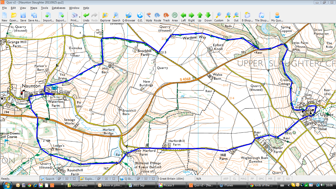
Sunday 25th September 2011 Naunton, Upper Slaughter, Glos

Mike & Robin
This was one of our traditional Sunday walks, done with Robin and Mike, but in Mike's favourite area around Naunton. Mike drove us from Cheltenham on a grey morning and we parked opposite the Black Horse pub, ready for the return later. The circular walk is 7 miles which we did in around 2.5 hours.

The Black Horse, Naunton

We walked back through the village and turned left beside the old dovecote (see walk of 9th March 2011 with Mike). We continued up the hill past the dovecote until we reached the golf course, keeping to the well defined track before turning to the left, across fields towards the ford at the Windrush. We met another group of walkers there who greeted us and when we told then we were doing a circular walk back to Naunton via Upper Slaughter, their leader scoffed, questioning our navigational skills. When we were out of earshot, we let them have it! But I think they heard - see later.

Lords of the Manor
We crossed the field, heading across and uphill until we reached tarmac and then followed the road for some time past farm buildings and other Cotswold gaffs. Beside Manor Farm, we entered fields again with the promise of a pit stop and coffee but the view that Mike had in mind for our stop was crowded out by a blue rinse walking group who greeted us loudly as we approached! We eventually found some space (!), had our break and continued into Upper Slaughter, passing the Lords of the Manor and other pristine houses, turning left in the village to meet two bus-loads of ramblers, one from Derby. We admired the houses in the village, cursed the Londoners and made our way past the sea of humanity in walking boots.

We left the village along the track by the River Eye, through woodland until we met the road again - this time stopping to admire a handsome gate house for Eyford Park, before moving on for a short while before following the Wardens' Way track again. We passed a row of workers cottages before taking the track - I don't suppose these are for workers any more! The track at this stage is quite easy and we were making good time as the rain/drizzle came down, covering us very quickly. We followed the track in a zig-zag until we came to Brockhill Farm where we began our descent down to Naunton. We actually met our sceptical tour leader and his group coming the other way, apologising loudly and theatrically that he/they should never question other folks' navigational skills! Sorted!

We arrived back into Naunton in the rain, changed and enjoyed Donningtons BB and SBA beers with lots of other walkers!

An OS view walk is below, courtesy of QUO digital mapping/OS


Wednesday, 21 September 2011

Wednesday 21st September 2011 Hazleton & Salperton, Glos

This is a short (5 miles) circular walk through rolling Cotswold Hills, done with Mike on a beautiful autumn day, sun shining, birds singing etc etc. We drove to the picturesque village of Hazleton, just off the main A40 and parked in the village before setting off along the track down towards a large, untidy farm yard.

I was relieved to see that a large gaggle of geese were restrained behind a fence as we approached, so we took time, in comparative safety, to look at the geese, ducks and other game birds being reared there. We passed through the smelly farm yard and started along the edges of fields which had been recently been ploughed. We continued until we stopped to look at an old barn at Downs Barn which Mike had explored on a previous walk - believing it to be the home of barn owls at some stage.

Back towards Hazleton
We started uphill at this stage (unusual for a Mike walk) on a gentle climb, criss-crossing fields, trying to keep out of the muddy parts by sticking to the edges of the fields and stumbling through the narrow tracks as a result. We joined the Gloucestershire Way at Lamp Acre where there was a very smart roadway, with well manicured trees and bushes either side - marking the entrance to Salperton Park. We crossed the cattle grid into the park and took a small detour to look at a view of the main house before retracing our steps and continuing the walk back towards Hazleton.
Salperton Park
Again we crossed fields and skirted the woods at Hazleton Grove before we saw the first few houses of the village. We passed the churchyard, admired a few village houses before we reached the car and took on liquids. We declined a lunchtime pint and drove back to Cheltenham - a good walk and all done, door to door in around two hours.


An OS view walk is below, courtesy of QUO digital mapping/OS