|
| Snowshill |
Another short walk (this time my sister's sore ankle was the reason!) with Ros and Dave round the picturesque village of Snowshill, near Broadway. This walk is just under 4 miles and is a circular route through farmland and hills surrounding the village and National Trust Manor House.
 |
| Snowdrops |
We parked in the car park on the road to Broadway, just on the edge of the village and quickly were on a well worn track going downhill across sheep grazing land. We passed through a number of gates and over stiles and started to gradually climb the opposite side of the hillside, leaving the muddy track but then having to negotiate barbed wire to return to the route. At the top of the hill, we joined a forestry track where we could see Broadway Tower in the distance. After a gate, we crossed a stile, joining the Cotswold Way for a while, following a track with a large farmhouse on the left and disused quarries where presumably materials were recovered for building homes and farms. We passed Littleworth Woods and then dropped into a field with Snowshill in the distance. We crossed the field, passing a couple of typical Cotswold gaffs, then joined the main road down into Snowshill, stopping to photograph the snowdrops which are very typical of the village - thousands of them!
 The sign at the Snowshill Arms asking folks to remove muddy boots on entry, encouraged us to walk on to the car and change into cleaner attire - then we enjoyed a pint and the fire in the Arms.
Snowshill Arms
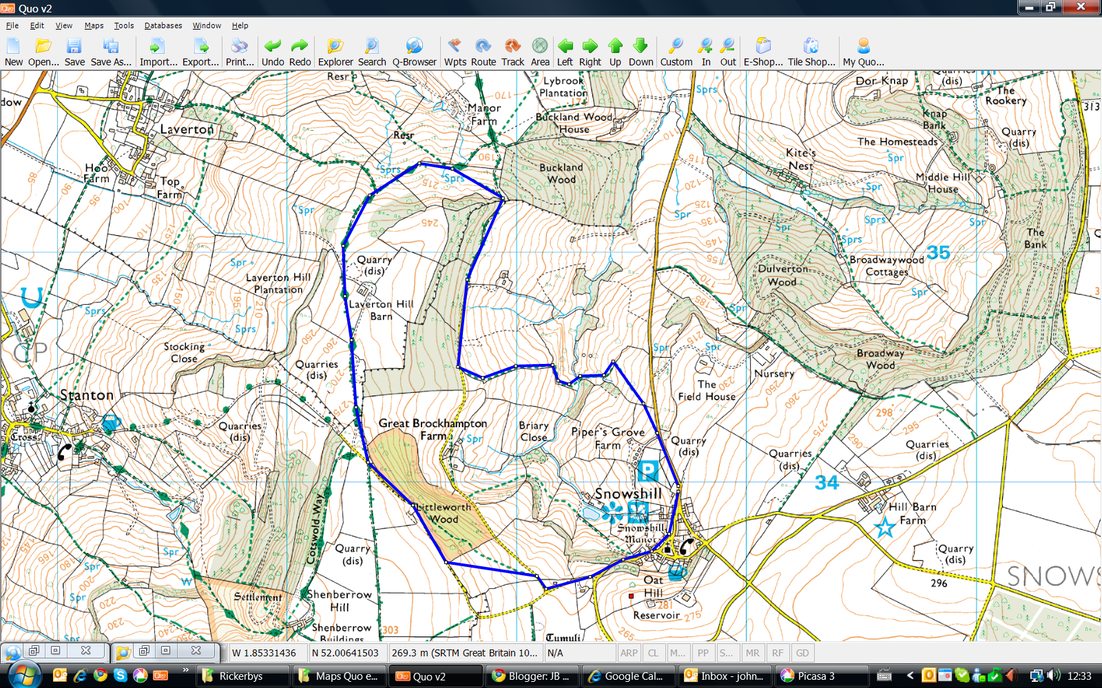
An OS view of the walk is below, courtesy of QUO digital mapping/OS:
A short walk of 3 miles, testing my sore ankle which has kept me and my boots separated for a couple of weeks.
 I did this walk with Anthony and Josie Gibbs who live in Wilmslow and who are regular walkers in the area, especially the Peak District. We drove from Wilmslow to Mellor by way of Marple and parked in the car park of the Pack Horse Inn approaching New Mills. It was a cold and blustery day, totally different from the weather we'd left behind in Wilmslow.
The Pack Horse Inn, New Mills
I did this walk with Anthony and Josie Gibbs who live in Wilmslow and who are regular walkers in the area, especially the Peak District. We drove from Wilmslow to Mellor by way of Marple and parked in the car park of the Pack Horse Inn approaching New Mills. It was a cold and blustery day, totally different from the weather we'd left behind in Wilmslow.
The Pack Horse Inn, New Mills
 Unusually, we had lunch first, before walking, as the timing would have been against us to do it the other way around i.e. the pub would have been closed. Quick pint and pub lunch was excellent, then on with the boots and off along Mellor Road before turning right onto a track through farmland and a farm. We walked along the edge of the golf course, passing the Mellor and Townscliffe club house and reached a stony track descending towards Brook Bottom where we passed the picturesque Fox Inn. We resisted the temptation to stop for another pint and passed by (!), heading up the hill out of the hamlet, along the track into more farmland. We kept walking up the incline, past farms and outbuildings until we reached a path at the crest of the hill, before heading downhill in the general direction of the Pack Horse Inn.
We passed through Castle Edge farm and at the strange house with the castle frontage, we turned right, downhill towards the pub where the landlady reminded us that it was 14:58 and they closed at 15:00! Even quicker half and off back to Wilmslow! Ankle fine and bodes well for more miles this week...
An OS view of the walk is below, courtesy of QUO digital mapping/OS:
This was a 6 mile walk with Mike Preston who had done this particular walk a couple of time before. Mike drove us to a good parking spot by the River Coln (OS Ref: SP 14406 04806) just outside of Coln St Aldwyns and we got booted up & ready to go. Gaiters and waterproofs were to hand as Mike predicted a 'sticky' walk through the farmland, particularly when we crossed the fields ahead of us.
 |
| Arlington Row |
We left the car by the 'private' fishing on the Coln and went through a gate just over the river towards farmland which increased in gradient slightly and off to the left. We walked through the fields passing through a farm and then onto a very short stretch of walking on the road until we saw a stile to the right and were again into fields and farmland. We followed a straight path towards Arlington Pike and took a sharp right towards Bibury where we could see the village ahead of us. The Catherine Wheel pub could be seen on the left as we entered the outskirts of the village and we passed several smart Cotswold houses before we descended onto Arlington Row itself. We passed the cottages and crossed the Coln via the small footbridge which takes you to the main road through Bibury. We followed the road and when it began to bend to the left, we took the right towards the village church. We went through the churchyard to the rear and went into the grounds of the Bibury Court Hotel by a convenient garden gate, then followed the river again towards the weir and bridge. We then followed a track past a fine Cotswold 'gaff' tracking the Coln again through Oxhill Wood, Ash Copse and returned to the starting point by the 'private' fishing sign where we parked.
 |
| Bibury Court Hotel |
There are several pubs worth visiting in the area:
Catherine Wheel, Bibury
The New Inn, Coln St Aldwyns
An OS view of the walk is below, courtesy of QUO digital mapping/OS:


 The sign at the Snowshill Arms asking folks to remove muddy boots on entry, encouraged us to walk on to the car and change into cleaner attire - then we enjoyed a pint and the fire in the Arms.